
I’m trying something new here. I’ve done 360 video walks before but this is more of a VR Tour. It’s new software to me so I appreciate your feedback on how I can improve the experience.
My intent is to give you a self-guided, self-paced 360 view of the trail so you know what you are getting into before you go. We think the Beaver Ponds Loop trail is one of the best hikes in Yellowstone for families.
This post is also over on YellowstoneTrips.com run by the wonderful @TravelingMel.
How to Use this Tour:
It’s pretty simple. Click on the tour and then navigate using the blue arrows at the bottom. If you’d like to see an overview map of the trail and maybe jump ahead to a specific spot, just click the teal “Pin” icon at the bottom of the screen. You can click any pin to jump to that point. To look around at any particular spot, just use your mouse to click and drag the photo around.
To make the tour “Full Screen” just click the full-screen icon in the bottom-center or right click and an “Enter Fullscreen” option will appear. Select that. Press the “Esc” button, click the small-screen icon, or right click again to exit Fullscreen mode. Scrolling up or down with your mouse’s scroll wheel should zoom in and out.
The Tour:
Trail Description:
The Beaver Ponds Trail (or Loop) is a very achievable 5.5 mile (8.9 km) loop hike that we love because we have felt very comfortable doing it with both young kids and grandparents. Of course, you’ll need to make your own decision based on your fellow hikers but hopefully, this description and virtual hiking tour will help with that. As always, be prepared with at least sunscreen, appropriate clothing, snacks, plenty of water, maps, and bear spray when hiking. Use good judgement and common sense. It offers plenty to see and lots of opportunities to stop for snacks (bring snacks).
The trail makes a 5.5 mile “loop” from near the Liberty Cap feature at the edge of the terraces up and around to the back of the Mammoth Hotel. Not a perfect loop, but close enough and you can get an ice cream at the Mammoth Terrace Grill afterwards. While you can hike it in either direction, we like to start at the Liberty Cap end because we get through most of the uphill bits early on. It leads through forest and has a fair amount of sagebrush open areas that can get pretty hot on summer afternoons.

The National Park Service lists this trail as having 350 feet of elevation gain but my GPS had total gain at 647 feet. Either way, it’s really not too bad, but the first 3/4 of a mile is mildly steep. If you take your time and rest when needed, the rest of the trail is pretty easy. The starting elevation is at 6280 feet (1917m) and tops out at 6780 (2066m) and should take 2-3 hours or more.
How to find the Beaver Ponds Loop Trailhead
You can find a small parking area between the trailhead and the Mammoth Hot Springs Restrooms. Be sure not to block the drive of the private residence there and be aware that this lot is also used for tour busses. The first bit of the trail is also called the Sepulcher Mountain Trail and is labeled as such on Google Maps. The trail spits midway up the hill and it’s clearly labeled and signed. There’s some signage at the beginning of the trail.

Starting at the Liberty Cap, you will almost immediately enter into the trees as you start your climb. This is the steepest section of the trail and it’s mercifully shaded. Pretty quickly you will cross a stream on a wooden foot bridge. At about .25 miles you see a trail leading off to the left that goes up to the upper loop of Mammoth Terraces. Stay right. Just before the top of the hill, at about .7 miles you will see another split where Sepulcher trail leads off to the left. Again stay right. The splits have signs and clear indications of which way to go. After that, just follow the trail and it will lead you all the way around.
I took the photos for this tour in early July and you will see plenty of wild flowers in the clearings of the forest. There’s a nice one at about 1.3 miles. So much color!!!.

There’s another small creek crossing at 1.9 miles with some nice shade in the trees. At about 2.5 miles, you’ll reach your first beaver pond. Interestingly, this is also right at the state line between Montana and Wyoming. I remember sitting down for lunch here one time with our little boys and a giant pileated woodpecker landed on a tree about 20 feet away. Speaking of wildlife, you are likely to see ground squirrels, forest and water birds, possibly a beaver, bison, and even bears up here. Be aware and be safe.

Depending on the time of year, you may encounter a muddy spot or two. This year, I found one at about 2.6 miles. Luckily there were some logs laid down that made it easily crossable. Not much further along, you’ll come across another small pond just as you enter the trees again for some welcome shade. Off to the left, you will come across another area that looks like it should be wet but the trail stayed pretty dry until you get to a small creek that you can cross using some rocks. The trail begins to descend here as it follows a creek and bends east at the base of a hill.
At 3.2 miles you’ll catch site of the third and largest beaver pond. The trail wraps around the east side of the pond and you will cross the dammed up outlet at about 3.5miles. You will shortly encounter your last bit of uphill here but it’s only about 150ft of gentle gain, mostly in the trees, over .5 miles. Easy, peasy. At the top, there’s an obvious overlook off to the left.

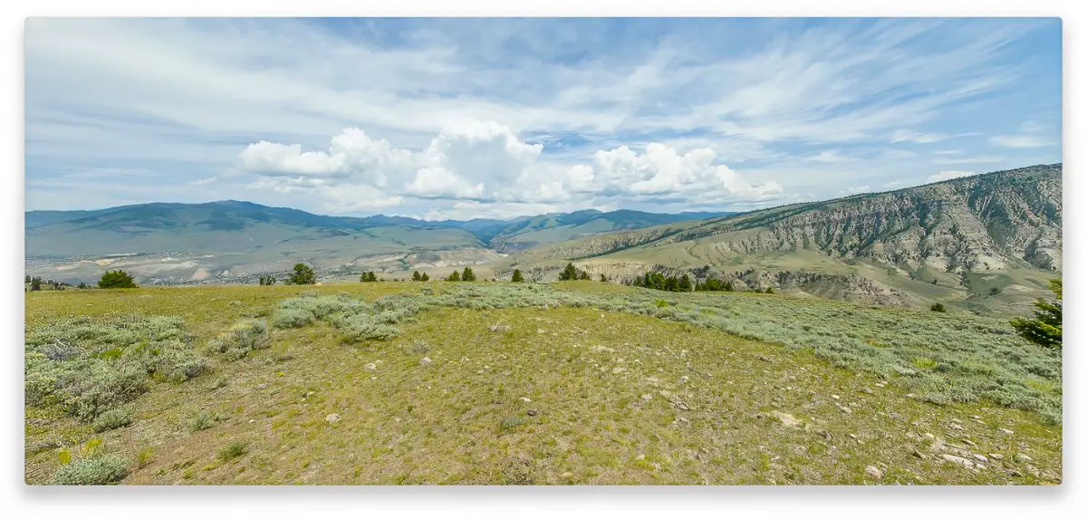
At this point, the trail goes through a section of open sage brush with wonderful views of Gardiner and the mountains to the east. Enjoy the scenery but make some noise. It’s pretty surprising how easily bears can disappear in this type of terrain if they are napping next to some sage. You will descend through some more trees and then level out into a long stretch of more open sage. Before the floods of 2022 took out the old northern access route, this section was quiet and peaceful. It still is, but the new access road now comes much closer and you may hear the occasional diesel truck or motorcycle. As you get nearer to Mammoth, you edge closer to the new road until at 5.38 miles you will find another trail sign and it drops down into the back of Mammoth Hotel and the Mammoth Ranger Station.

Head to the right (Southwest) to the Mammoth Terrace Grill for ice cream and beverages, or if the lines are too long, you can keep going to the General Store for grab and go options.
Please let us know how we can better improve these virtual walks, what you like and don’t like, any questions about using them you might have, etc.
Support us for just $5 on Patreon
Or make a one time Paypal Donation